What’s this?

The geophysical survey Down-Hole type is a survey technique in hole, very accurate and precise, which is used for the determination of physical – mechanical properties of the materials constituting the subsoil.
What’s it for?
By means of the Down-Hole technique, it is possible to determine the vertical propagation velocity (mean and interval), of seismic compression waves (P) and of transverse or shear waves (S). The Down-Hole methodology presents, the advantage of not having as a condition the necessary increase in speed with depth as they evaluate the arrival times of elastic waves as they penetrate the deeper layers without undergoing refractive phenomena. This makes it possible to evaluate any speed reversals within the package of lithotypes encountered in drilling.
How to do it?

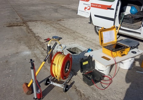
The technique is based on the measurement of the travel times of elastic waves between the seismic source placed on the surface and the geophones positioned inside the borehole, suitably conditioned with PVC pipe or geotechnical pipe. The Down-Hole type seismic system is carried out by placing one or more triplets of sensors (horizontal and vertical) inside a borehole to receive the seismic signals generated on the surface. The energization will be performed by means of a perturbation by means of a mechanical source, in phase inversion in order to polarize the phases S on a horizontal plane H according to an orientation of 180. Seismic velocities Vp and Vs provide information such as elastic modules and geoseismic parameters. On drilling holes extended up to 30 meters of depth it will be possible to size the parameter of Vs30.
Analysis of the results allows to evaluate the seismic velocity – depth function, both for compressive waves P and for transverse waves S; The data thus obtained allow to associate the seismic velocities to the strata identified during the execution of the mechanical survey and to evaluate the characteristic mechanical parameters (Elastic Dynamic Modules).
Areas of application:
Following an accurate data processing by means of specific calculation software, we can obtain very detailed information about the subsoil that are essential for many areas of work:
- The stratigraphy of the alluvial coverings on the bedrock.
- Classification of the foundation land according to the NTC 2018.
- The location of fractured areas.
- The seismic microzonation.
Condividi questo Articolo


